Cairo Top Tours
Cairo Top Tours

Latest Articles

  • Al-Hakim be Aamr Ellah Mosque

    Mosque of al-Hakim bi-Amr Allah

    Al-Hakim Amr Allah Mosque, located on Al-Moez Street in Old Cairo, is a prominent Fatimid landmark and the fourth oldest surviving mosque in Egypt. Built in 380 AH during Al-Aziz Billah's reign, it was completed by his son in 403 AH (1012-1013 AD), making it the second largest mosque in Cairo after Ahmed Ibn Tulun Mosque. The mosque's name was attributed to him. The mosque, measuring 12005 meters in length and 113 meters in width, has two minarets at its sea front, surrounded by pyramid-shaped bases. The upper cubes are slightly backwards, and an octagonal minaret protrudes from each of the upper cubes.

  • Visit Queen Nefertari’s Tomb

    Tomb of Queen Nefertari

    There were also the great queens of the New Kingdom (1550-1090 BC) Nefertiti, the wife of Akhenaten (1371-1355 BC), and Nefertari, one of the celebrated eight wives of Ramses II (c. 1279-c. 1213 BC). While Nefertiti is more popular for the exquisite portrait bust of her that is located in Berlin, Nefertari is famous mostly for her large burial site situated in the Valley of the Queens.

  • tomb of Tutankhamun | Tutankhamun tomb discovery | king tut tomb pictures

    Tomb of Tutankhamun

    The Valley of the Kings, located on the Nile River's west bank near Thebes, served as a cemetery for pharaohs during the New Kingdom of Ancient Egyptians from 1539 to 1075 BC. The 20,000 square meter rocky valley houses 27 royal tombs from the 18th, 19th, and 20th Egyptian dynasties, which have been discovered to this day. Pharaoh Tutankhamun, also known as King Tut, was the last Eighteenth Dynasty Pharaoh from 1334 to 1325 B.C. He is famous for his intact tomb and treasures, unmarked grave, and premature death due to broken bones. His minister married his widow after his death.

  • the Virgin Mary’s tree.

    The Tree of Virgin Mary in Matareya

    The Coptic Orthodox Church commemorates the Feast of the Entry of the Holy Family into Egypt, a minor liturgical feast. It commemorates St. Joseph the Carpenter's obedience to an angel's command to take the child and his mother to Egypt, marking the entry of the Holy Family into the land of Egypt. The prayers begin on the eve of the liturgical day. The Maryam Tree Mazar, a significant tourist attraction in Egypt, is home to the Holy Family and has undergone significant development and renovations to maintain its historical significance.

  • Biography of Ahmad ibn Tulun

    Biography of Ahmad ibn Tulun

    Ahmad ibn Tulun's Turkish roots trace back to his father, who was a slave of Noah ibn Asad, the governor of Bukhara. Asad freed him, and Caliph Al-Ma'mun admired him. He was enrolled in the caliphate court and eventually became the head of the caliph's guard. Ahmad bin Tulun, born on September 20, 835 AD, in Baghdad, the capital of the caliphate, was well-cared for by his father, who taught him military arts, jurisprudence, hadith, and hadith, and encouraged him to learn from scholars and read the Qur'an.

  • Al Qusayr, Egypt | Al Quseir history

    Historical Background | Quseir Town

    The city of Al-Qusair is located on the western shore of the Red Sea in Egypt, 140 km south of Hurghada, and one of the most important villages of the city is Hamrawin village, with an area of 7,636 km², while its population is 50,023 people. Al-Qusayr, named after a fort that protected the nation during ancient Pharaonic, Roman, and other empires, was a hub for gold procurement by Pharaohs. Built by Sultan Selim I during the Ottoman period, the fortress remains intact.

The Roda Nilometer in Cairo

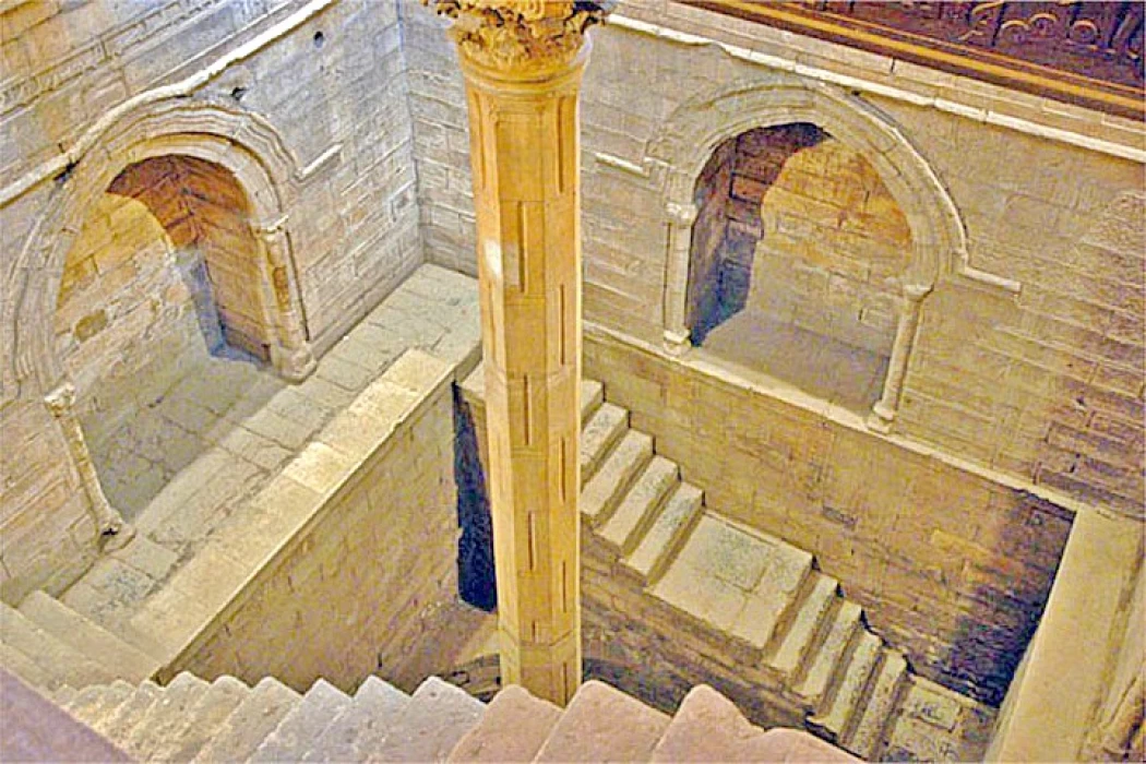
Informations about The Roda Nilometer in Cairo

  • 05 16, 2023

Informations about The Roda Nilometer in Cairo

The Nile was of vital importance to the rulers of Egypt since it was the main artery upon which the lives of the Egyptians depended. This explains why floods were tokenized by border taxes.

These rulers made efforts to ensure fairness by measuring the water level in the Nile for collecting agricultural land, as lands that are flooded by the Nile are different from those that are difficult to irrigate.

There were many gauges along the Nile River, including a gauge in Anasna, another in Manaf, a gauge in Qasr al-Shamaa and other gauges, which stopped working in 247 AH (861 AD), when the Nile gauge was erected in Rawda and relied on. (861 AD), where the Nile gauge was established in Rawda and relied on it.

The employee in charge of the gauge was known as the owner of the gauge, and he measured the increase in the gauge every day in the afternoon, and he also compared the level of the increase in water every day with the previous day of the previous year.

Since the centralized administration of the state was established, the ancient Egyptians continued to record the level of the Nile in official records. The earliest records of flood levels appear on the Palermo Stone, from the fifth Egyptian dynasty; it bears 63 records of the Nile's water levels. Measurement continued, and developed, until 715 AD, when the Nile Gauge, or Rawda Gauge, was built on Rawda Island.

This scale continued to be used until the beginning of the 20th century. Monitoring the level of the Nile had an impact on estimating the value of taxes and the areas that could be irrigated during the year. After the flood, the provinces were responsible for managing the canals and irrigation canals, while land and water levels were measured at the national level. It is considered an example of Islamic architecture in Egypt.

The Nile was also important to the spiritual life of ancient Egypt. They worshipped Hapi, the god of the annual floods, and believed that only Hapi and the Pharaoh were able to control the flood. The Nile also became the basis of the ancient calendar according to the three cycles of the Nile, although the idea of Nile gauges began in ancient Egypt, they continued to be used by later civilizations.

This Nile gauge is the oldest Islamic water-based structure and the second oldest Islamic historical site after the Amr ibn al-As Mosque. It was built by the Abbasid Caliph al-Mutawakkil al-Abbasi in 861 AD. The walls and roof were added by Al-Zahir Babars. 

Tags:
Share On Social Media:

Egypt Tours FAQ

Read top Egypt tours FAQs

To predict the size of the crops from year to year, the ancient Egyptians built a series of wells called Nilornetri, one of which is still visible, carved in the rocks of the island of Roda.

A long time ago, people in Egypt used a special tool called a nilometer to figure out how much food they could grow and how much money they needed to give to the government. Recently, scientists found one of these special tools in the old city of Thmuis in Egypt.

Yes, visitors can access the Roda Nilometer and explore its chambers and measurement shaft. The site is open to the public, allowing visitors to learn about the history and significance of this ancient hydraulic structure.

;

Cairo Top Tours Partners

Check out our partners

EgyptAir
Fairmont
Sonesta
the oberoi