Bahariya Oasis Egypt
Bahriya oases, the paradise of the western desert of Egypt, has a history with a past and a determination that is found in the heart of reality, in which hope and ambition are shared.
Bahriya oases have a charming nature in terms of location, good climate, the vastness of the desert, clean air, and beautiful green parks, and all this reveals a good future for this wonderful beautiful spot such as investment, recreational tourism, and medical tourism.
Bahriya oases are characterized by ancient Pharaonic, Roman, and Greek monuments, as this spot has heritage, culture, customs, traditions, and features that express the nature of the place and its beauty.
Location
It is part of the western desert and is located 365 km southwest of Cairo to the north of the New Valley governorate and the south of the Qattara Depression it is connected to Giza by a paved road and it is connected to the Farafra Oasis by a 200 km road
Climate
Moderate sunny dry winter and very hot summer in the daytime and moderate at night
The area
The total area of the Marine oases is 12,000 km (half a million acres ) and the main geological formation in the Oasis is the Nubian Sandstone, which is the water-bearing layer forming the underground reservoir of the Western Desert
Natural possibilities
Mountains interspersed with valleys filled with palms, olives, apricots, and intertwined trees form green blocks that give a breathtaking view that is not matched by a similar landscape in the Valley. The mining resources are represented by the presence of minerals such as Iron, where there are the most reserves of iron ore in the Middle East, and this is evident in the natural and color composition in the mountains and highlands of the Oasis, which is covered with black color, which is unique to the oases of the Western Desert
It is also characterized by the presence of cold and hot mineral and sulfuric waters, such as the eyes of the wise well "warm 65 degrees Celsius" and the Ain Halfa well in Al-bawiti, where the natural eyes reach 400 eyes in various Oasis areas in addition to hunting areas for ducks, deer, and migratory birds
Population
The population is 48,720 thousand people, distributed over six villages, namely Al-bawiti, the capital, where most of the services are concentrated, and the village of Al-Qasr is adjacent to Al-bawiti and forms one residential block, and the other villages are far apart from each other, namely: mandisha, Al-Zubu, Al-Qabala, Al-agouz, Al-Hara area and consists of Azab ain Jubeir, Ain al-Wadi, ain Youssef and about 40 km away is the village of Al-Haiz and consists of Azab are ( drum Ammon, Azza, Rais, Ain Sheikh, Arabic )
Industry
Bahriya oases are famous for the date industry, and the most famous factories are located in the cities of Al-bait, Manisha, and Zubu, and export a large part of their production to the Maghreb countries and Southeast Asia.
Agriculture
Bahriya oases are famous for palm cultivation, as they include half a million palms producing about 40 thousand tons/year of the finest types of dates, and the cultivation of apricots, olives, citrus, greens, and aromatic plants.
The name of the Bahariya oases began to appear after the fall of the thirteenth dynasty and the beginning of the Hyksos rule, and it was known as ZS with the beginning of the 26th Dynasty, the Bahariya oases entered the greatest periods of their history and most of their effects date back to the era of this dynasty.
The palace area and its most important places :
Ain Al-muftla area
It is a high Sandy plateau in the village of Al-Qasr overlooking agricultural areas surrounded by a group of mountains and plateaus, there are four temples, each independent of the other, and there is also a temple dating back to the Safavid era, family 26
Sweet Continent region
It has the Tomb of the first ruler of the oases of the Navy, Amenhotep Hawi, and the tomb is engraved and colorful and dates back to the 18th dynasty and the first half of the 19th Dynasty.
Adoption area
It has the temple of Alexander the Great, which is the Second Temple to be built in the western desert, and the maroon, DAST, and Magharafa areas, which are among the most important mountainous areas with a unique character.
The Great Temple in the palace area
It was built on a large area of limestone sandstone from the era of the 26th Dynasty during the reign of King Ypres and Ahmose II.
Al-bawaiti city
It is the current capital of oases and the most important archaeological places in it:
Yusuf Salim district
It has six engraved and colorful tombs.
Broiler area
It has the largest cemetery dating back to the Ptolemaic era dedicated to the burial of the bird APIs.
Sheikh Sobey district
It has six engraved and colorful tombs.
The archaeological zone of the space
There are several churches, palaces, cemeteries, and tombs dating back to the late Roman periods.
The villages of Al-Zubu, mandisha, Al-Hara, Al-Qabala and Al-Agou
These villages are characterized by the presence of Rocky and sandy hills in many parts, and in the ancient and modern eras, they relied on agriculture based on groundwater.
Most of its monuments are around agricultural areas, ancient eyes, and Roman ruins.
Panentio cemetery
It is a pharaonic tomb discovered in 1938 and dates back to the 26th Dynasty the historical importance of this tomb is due to the knowledge of the style used in the method of drawings, inscriptions, pharaonic fonts, and colors.
Valley of the Golden Mummies cemetery
A huge number of Golden Mummies have been found, estimated at ten thousand Golden Mummies, most of these mummies have masks and gilded chests decorated with hieroglyphic inscriptions and religious drawings.
It was discovered by the Egyptologist Dr. Zahi Hawas in 2000 AD .
Tomb of the ruler of the oases (grandfather of khansoyov Ankh )
From the 26th Dynasty of the Pharaonic era, it is located inside the city of Al-bawiti in the Sheikh Subi area, and many stone coffins were revealed next to it, along with artifacts and statues known as (Al-ushabti)
There are also marine oases:
Holy EPS cemetery
It is a necropolis from the Ptolemaic era of the ibis bird and is located on the AL-furuj plateau, containing a collection of sacred animals that were offered as mummified offerings to the gods.
Church of St. George
It is located in the AL-Heiz area about 40 km away and was built between the fourth and fifth centuries AD and it is believed that this church has the remains of a headless body that is claimed to be one of the apostles of Christ.
Cape monastery
It is located in the El-Hez area, at a distance of 1/2 km south of the Church of St. George.
Temple of Alexander the Great
It is located northeast of the palace and its importance is because it is the only place where there was a cartridge in the name of Alexander the Great, and Alexander the Great ordered its construction and dedicated it to the idols Horus and Amun during his passage through the Bahariya oases on his way to Siwa Oasis.
Cultural tourism and attractions
The oases are characterized by the presence of many Pharaonic and Roman monuments and provide services to visitors to these areas to encourage this type of Tourism.
Medical tourism
The coolest thing you see is the water flowing from the sulfuric eyes, which number up to 400 eyes, these waters are sulfuric and mineral water, some of which are hot and their temperature exceeds 70 degrees Celsius, which approaches the boiling point, and most of them are cold water, and most of the eyes are suitable for hospitalization from various diseases, especially rheumatism, rheumatoid and asthma, and the most famous
Al-Qassa'a Wells area
It consists of three close residential communities with a group of hot sulfur wells up to 45 degrees Celsius, adjacent to two mountains known as Dust and the Scoop with stunning natural colors, and a dinosaur skeleton was discovered in this area dating back millions of years.
Roman Wells
It is a historical trace of a well that represents a deep natural rock break whose water reaches the farming areas at a distance of 10: 15 km through a group of historical Roman Wells
Airport well Area
It is a spacious flat plain with a well for sulfuric water and a densely planted area.
The peshmo well
It draws its water from two sources, one cold and the other hot, ending in a deep rocky stream
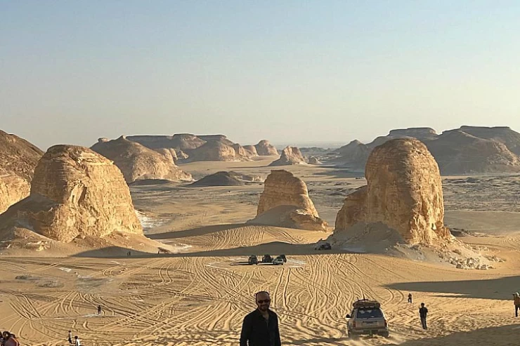
Safari tourism
The oases enjoy the charming desert areas that qualify them to become one of the best safari tourism areas, which is tourism that depends on driving cars on off-road roads and dunes to see the wonderful mountain areas such as the White Desert by Farafra road.
The most important of these areas are :
The Magic Eye
It flows from a small hill containing a very dense group of palm trees in the middle of the flat desert, perhaps the name is because despite the continuous flow of Ain Sokhna, The Hill remained the same and the surrounding area did not turn into an oasis, and this has led to an oasis, and this has led some to believe that the flow of the eye stops after the departure of visitors.
Crystal Mountain
It is located north of the white desert area and is called ( Jabal al-izzaz ) and is based on rocks of transparent quartz that look like glass or crystal.
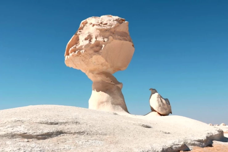
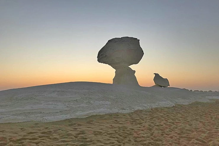
The White Desert of the Farafra Oasis
The White Desert is considered world-famous, as it is visited by tourists from all over the world, it is also characterized by being close to the Bahariya Oasis Road, and there are the best camping sites nearby.
It became a nature reserve in 2002, where it publishes a large number of amazing formations formed as a result of the winds, as well as beautiful rock formations that characterize this desert unlike any other in the world.
It was named the White Desert because it has a white color that covers most of its parts, and its total area is 3010 square kilometers, it also has a huge Cretaceous rock, the desert contains many formations that were formed as a result of an accidental sandstorm in the region
A Nature Reserve is defined as any area of land, coastal or inland waters characterized by its flora, fauna, or natural phenomena.
These reserves aim to preserve various natural resources and also contribute to the preservation of the cultural and cultural heritage of many important areas.
These reserves are (dust and scoop-English Mountain-Black Desert)
Dusting and scooping
It is considered a rare geological heritage because it has been a research area for vertebrate fossils since 1910 with the discovery of the first Egyptian dinosaurs in addition to the accompanying fossil animals
English Mountain
It is located in the area between the village of Mandisha and the city of Al-bawiti and was so named because the English forces concentrated on it during the British occupation of the Oasis.
This mountain is characterized by its blacktop because it contains dolite and basalt stones, which are volcanic rocks, and its tourist importance is due to its location in the middle of the Urban range in the Bahariya oases, as well as the presence of a Roman water well at the top of the mountain overlooking the surrounding agricultural areas.
The Black Desert
Located between the Bahariya oases and the New Valley, they are limestone rock formations and Black Mountain Highlands formed during the volcanic era.
It was named this name because the air has oxidized manganese in the rocks, making them black, and this reserve is characterized by isolated hills, which vary in their sizes, configurations, and heights, which range from 150 M to 390 m, as well as their shapes, some of them are dark color consisting of delorite and iron quartzite, and some tend to be reddish, where the surface rocks consist of iron sandstone and a few of these hills consist of white limestone and are exploited as one of the means of attracting tourists, as they contain in some of its parts, iron oxides have red, orange and yellow colors, and this is evident in the Black Mountain region.
Bahariya Oasis which Means the northernmost Oasis because it is the closest to the Mediterrenean from the seven major Oases of the Sahara desert in Egypt, it consists from a group of villages the central most is called Bawiti.
Bahariya Oasis in Egypt Bahariya Oasis is located 330 km southwest of Cairo and 180 km from the Nile Valley, on a natural depression of 2000 km2, in a mountainous site. In ancient times Bahariya was considered a bridge between Egypt and Libya, ruled by a Libyan family under the control of the Pharaohs of the 26th Dynasty. It was called 'Little Oasis' as opposed to Kharga.
Bahariya is controlled by pharaonic power from the 6th dynasty, as attested by the presence of mastabas in Balat where the governors of the oases rest. In the Middle Kingdom, the trade region with the Nile Valley; a stele of the twelfth dynasty attests to political relations with Abydos and Thebes.
Additionally, Bahariya gained worldwide attention in 1996 with the discovery of the Valley of the Golden Mummies, where over 250 beautifully preserved Greco-Roman mummies were found, shedding light on burial customs and wealth in the oasis. Tourists today can also visit the Temple of Alexander the Great, the only known temple in Egypt bearing his name, making Bahariya a destination rich in both natural beauty and archaeological significance.
Bahariya also holds deep historical significance. It came under pharaonic rule during the 6th Dynasty, as shown by the mastabas in Balat, the resting place of oasis governors. During the Middle Kingdom, Bahariya functioned as an important trade region with the Nile Valley. A Twelfth Dynasty stele documents political and commercial relations with Abydos and Thebes.